Berkeley Tsunami Advisory: What to know and what to do
Residents should stay away from the water and the coastline — but do not need to evacuate, Berkeley officials said.
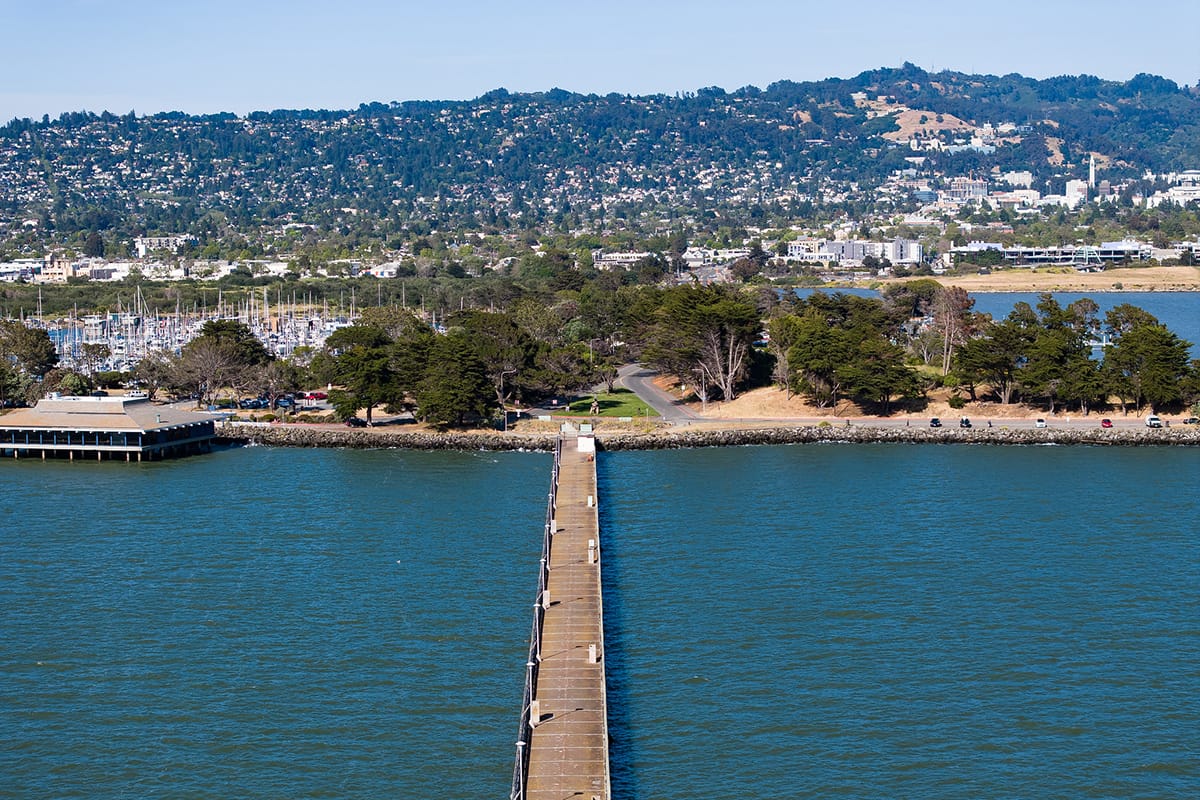
Update, 11 p.m. Boaters who live in the Berkeley marina do not need to evacuate given the conditions expected when the tsunami hits, the city says.
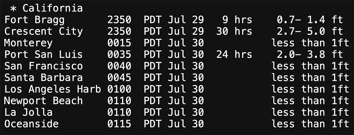
The tsunami surge, which is expected in the San Francisco Bay at 12:40 a.m. Wednesday, "is expected to be less than 1 ft tall," the city said in a Nixle alert.
"Be aware that this event could create strong wave action and strong currents in the Berkeley Marina," the city said. "Ensure your boat is tightly secured."
State officials say Berkeley, which has a "Phase 1" classification, does not need to evacuate its boats and docks at the marina.
Berkeley liveaboards, however, have been offered a discounted $75 rate overnight at the DoubleTree Hotel in the Berkeley Marina.
"City officials will continue to monitor the situation and … provide updates via AC Alert, Nixle, and on the Berkeley Emergency Map," the city said.
The city of San Francisco said "dangerous currents" are expected there at 12:40 a.m. "and may last for many hours. Move away from all San Francisco beaches, harbor or marina docks, or piers now," the city announced at about 10:15 p.m.
The city of Monterey, where tsunami activity is expected earlier, at 12:15 a.m., has issued an evacuation order for its harbor.
⚠️TSUNAMI ADVISORY remains in effect for the California coast. Stay away from the water! Stay away from beaches and waterways! Remember: Tsunamis are series of waves carrying large masses of water. The first wave may not be the largest! Do NOT go to the coast!! #CAwx #Tsunami pic.twitter.com/AQ7rCrTwmU
— NWS Bay Area 🌉 (@NWSBayArea) July 30, 2025
View the graphic larger.
Update, 7:35 p.m. Alameda County has urged residents to avoid coastal areas, beaches and waterways due to an active Tsunami Advisory, but says evacuations are not needed at this time.
The county issued an AC Alert announcement just after 7:20 p.m. advising that Bay Area tsunami activity was expected to begin Wednesday around 12:40 a.m.
Under the advisory, there are no areas where anyone in Alameda County has been advised to move inland or head to higher ground.
Berkeley officials said they hope the advice holds.
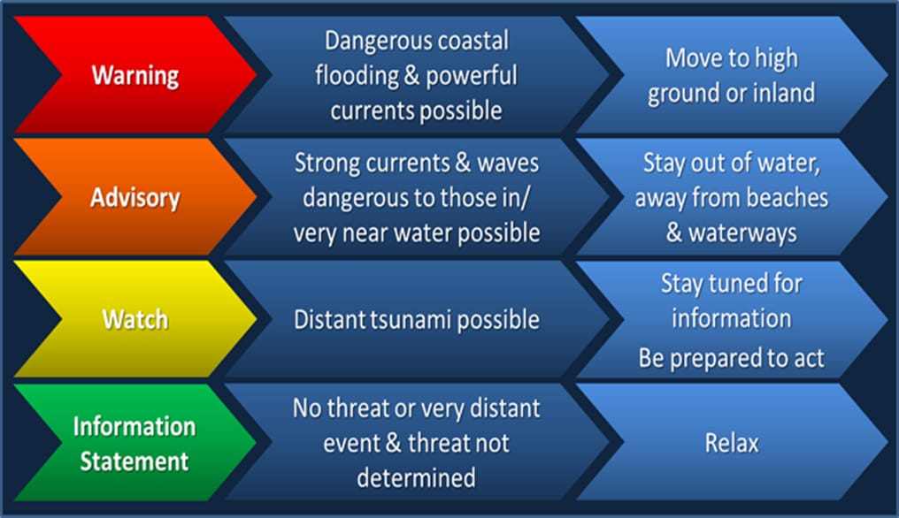
In its notice, AC Alert said there are four types of tsunami notifications, from information statements (which have the lowest level of risk); to a Tsunami Watch ("stay tuned"); a Tsunami Advisory ("stay out of the water" and away from the coast); and Tsunami Warnings, where people are told to "move to high ground" or head inland.
See the latest information and alert details from the National Weather Service.
Writing on X, NWS Bay Area urged caution near the water.
"Friends please be aware, a Tsunami is a series of wave carrying a large extra mass of water to our coast. This will NOT be a single wave. Do NOT try to go to the coast to take photos," NWS Bay Area wrote. "You're not just putting yourself at risk, you will also be putting rescue teams at risk."
Friends please be aware, a Tsunami is a series of wave carrying a large extra mass of water to our coast.
— NWS Bay Area 🌉 (@NWSBayArea) July 30, 2025
This will NOT be a single wave.
Do NOT try to go to the coast to take photos.
You're not just putting yourself at risk, you will also be putting rescue teams at risk. #CAwx https://t.co/u7kfCl6y05 pic.twitter.com/VZSIFhbbKd
Original story, 6:53 p.m. A Tsunami Watch is in effect in the Bay Area "until further notice" following an 8.8 magnitude earthquake off the coast of Russia.
Shortly after 6 p.m., Berkeley's city manager said its Office of Emergency Services is monitoring the situation and will share information as needed.
Authorities are asking everyone to avoid the water and local shorelines.
Writing on X, NWS Bay Area said community members should "prepare to evacuate coastal regions" and urged people to monitor local media as well as NOAA Weather Radio.
⚠️TSUNAMI WATCH in effect for the California coast. Estimated time of arrival as early as 12:15 AM on July 30. People along the coast: Stand by for further updates. #KnowYourZone at https://t.co/Dm0UehpMVM #CAwx #Tsunami pic.twitter.com/MLAkSPIJzL
— NWS Bay Area 🌉 (@NWSBayArea) July 30, 2025
According to current NWS estimates, the tsunami is expected to arrive in Monterey at 12:15 a.m. Wednesday and in San Francisco at 12:40 a.m.
The National Weather Service said coastal flooding is possible, with threat evaluations underway.
Berkeley says more tsunami details coming soon
West Berkeley City Councilman Terry Taplin said Alameda County will be sending out emergency messaging soon via the AC Alert system.
Taplin urged everyone in the covered areas to maintain an evacuation plan, sign up for Berkeley disaster preparedness training and review the tsunami chapter of the Berkeley's Local Hazard Mitigation Plan for further details.
NWS encouraged people to review tsunami maps from the California Department of Conservation.
(As of publication time, that website did not appear to be loading.)
This story was updated after publication due to the developing nature of events.
Related resources from the city of Berkeley