In Berkeley disasters, early evacuation is key: new study
"Early evacuation is the best course of action," said retired Councilwoman Susan Wengraf. "The longer you wait, the harder it's going to be."
The best way to stay safe from wildfire in the Berkeley Hills is to leave the area on extreme fire weather days before being ordered to evacuate, a new city study has found.
The detailed two-year analysis, released this week, estimated how long it would take people to evacuate during wildfire from the hills and tsunami along the shoreline, using computer modeling of traffic patterns during hazard events.
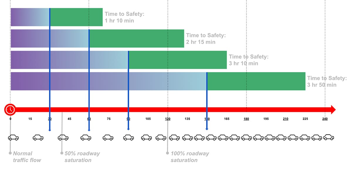
That could mean more than four hours in a major wildfire and more than two hours in a tsunami.
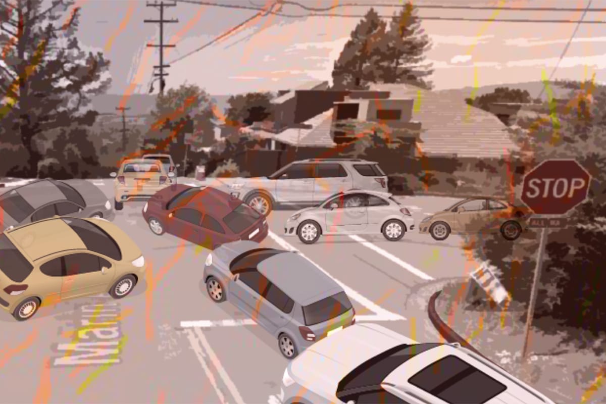
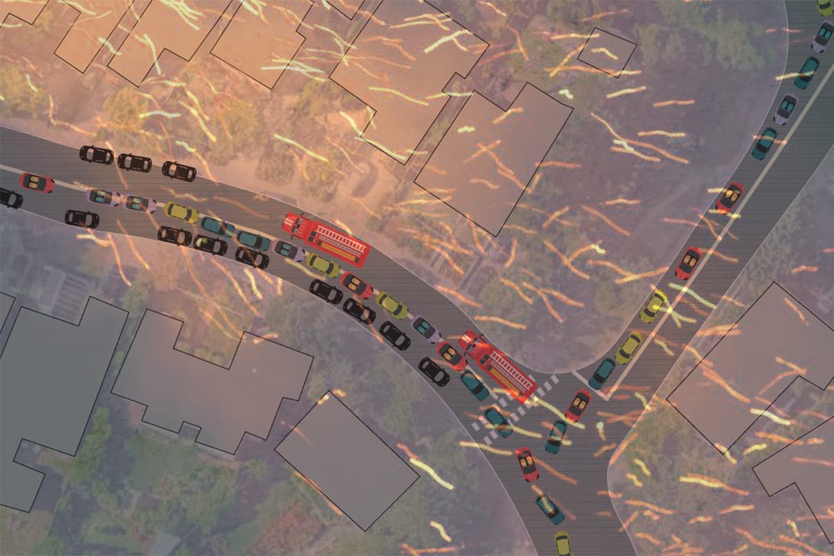
Clogged roads and standstill traffic during a wildfire evacuation could make it impossible for some people to drive out of danger, the study found.
It predicts perilous logjams on smaller and larger streets leading out of the hills, especially at intersections.
"The study gives us evacuation times and congestion patterns. When we overlay modeling for how we expect fires to spread under extreme fire weather conditions, we can see that there will still be people on the roadways as a fire spreads into Berkeley," said Sarah Lana, the city's emergency planning manager.
For years, Berkeley Fire Chief David Sprague has stressed the value of leaving hill neighborhoods on extreme fire weather days, especially for anyone who might have problems with a quick evacuation, including those with mobility problems and families with young children.
The study affirms the importance of this advice, Lana said.
"It's going to be so much easier to leave early when a fire hasn't started," she said. "For the most part, the study confirmed approaches we were taking and backed those up."
"That there will still be people on the roadways as a fire spreads into Berkeley."
In a major fire, it could take more than 4 hours to leave
Extreme fire weather, which has occurred on only four days in Berkeley since the city started using the designation in 2018 — in October 2020 and 2024 — are notched up Red Flag Warning days, when local weather data shows unusually dangerous fire conditions, such as strong winds that are hot and dry, high temperatures and low humidity.
All of Berkeley's major wildfires have occurred at these times.
In Red Flag conditions, which are determined by the National Weather Service, Berkeley Fire solicits detailed local forecasts, which form the basis for declaring extreme fire weather, Lana said.
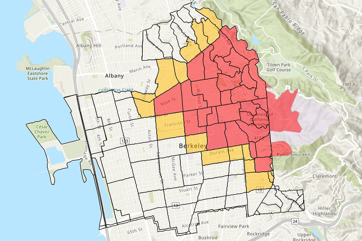
The study's estimated evacuation times from the hills during an event similar to Berkeley's historic 1923 fire — which started in Wildcat Canyon open space just east of the city and spread downtown — range from an hour and 35 minutes to four hours and 10 minutes.
For a Panoramic Hill evacuation, estimates range from 45 minutes to an hour and 45 minutes.
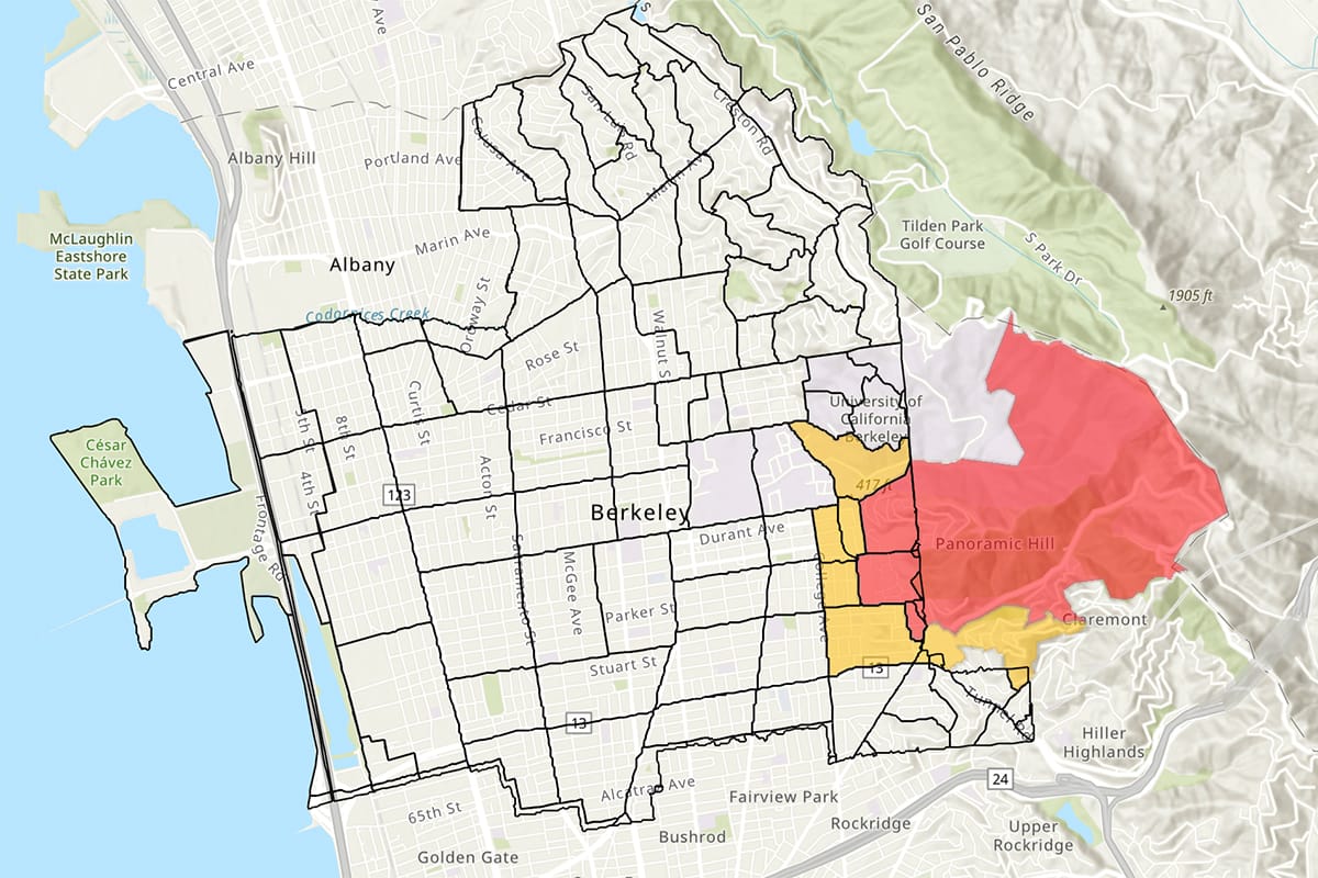
Berkeley Fire has determined that Panoramic Hill and a residential slice between Grizzly Peak Boulevard and Tilden park are the most likely places for wildfire to spread into the city from open space to the east.
In its newly adopted EMBER program, the department focuses its strictest wildfire mitigations in these areas, to help create a buffer to slow or stop fire.
The study also identified a few other areas most vulnerable to evacuation gridlock, including to the south and west of UC Berkeley and its Clark Kerr Campus, north of Ohlone Park and around the Lawrence Berkeley National Lab.
The 323-page study, which includes numerous recommendations, looked at evacuation at different times of the day and week, on all roads in the city, and included attention to people without access to transportation or close social ties, as well as the needs of medical facilities and schools, from preschool to university, people with disabilities, and pets, among other groups and situations.
The study backs the critical importance of emergency planning, Lana said, such as knowing potential evacuation routes, identifying places to go or stay, determining the special needs of family or household members, and arranging car pools with neighbors.
Particularly important is signing up for emergency notifications to get advisories, warnings and evacuation orders in a variety of hazardous situations.
Reduced Berkeley Hills parking won't help residents get out
In a surprise to Lana, and others watching Berkeley wildfire planning, the hill's evacuation traffic risks hold true even if the city enacts stricter parking restrictions on narrow roads in wildfire hazard areas, an idea called Safe Passages that's been in the planning for years.
Modeling scenarios looked at roadways with and without parked cars.
"I think we went into this thinking we'd look at more areas to red curb, that was the expectation," Lana said. "But these experts are guiding us with different expectations."
"The biggest reframe from the study… is the idea that moving parked cars from narrow roadways would not give the level of overall impact on evacuation that we expected. You can help a driver get down the street a little better, but we're trying to improve impact to a much larger area. The bigger issue is the volume of traffic," Lana said.
"Moving parked cars from narrow roadways would not give the level of overall impact on evacuation that we expected."
"The red curbing was a huge surprise," said former Councilwoman Susan Wengraf, a strong Berkeley wildfire preparation advocate who championed the evacuation study.
Before her retirement, Wengraf represented the high fire hazard District 6, now under Councilman Brent Blackaby, for 16 years.
"It's clear that early evacuation is the best course of action. The longer you wait, the harder it's going to be," said Wengraf, who continues working on wildfire issues regionally.
Wengraf was also surprised, and concerned, that the study doesn't recommend walking or biking to evacuate from a wildfire.
This includes using Berkeley's historical pathways, running up and down the hillside, which have been touted in the past by the Berkeley Path Wanderers Association (which maintains them) as helpful evacuation options.
The city said that's because people could be more vulnerable to heat, smoke or dangerous gases if they are on foot or bike.
Wengraf said she'd still like more information on the cons and pros of the pathways.
And Lana ultimately emphasized that, whatever the mode of travel, the timing is what matters most.
"The best choice for everyone… is to leave the hills when the fire department declares extreme fire weather," she said.
Parking restrictions may help firefighters get in
While not a panacea, the study did find that street parking restrictions could be helpful in other ways.
While it won't make a big difference for drivers leaving the hills — because of the sheer volume of vehicles heading in the same direction at the same time — it could help firefighters get in.
Fewer parked cars could make it easier for fire engines and other emergency vehicles to reach fire lines. They'd be moving in the opposite direction of traffic.
City transportation and public safety staffers plan to explore this, Lana said.
"Selective parking restrictions on larger Berkeley Hills roadways could help us establish a lane of traffic for fire engines to get in during an evacuation," she said.
Road design, especially in some areas of the city, could also hinder speedy evacuation, the study said.
To reduce congestion, the study recommends using adaptive traffic lights that automatically adjust to real-time traffic patterns. Permanent traffic calming measures, such as circles, speed humps and diverters, slow traffic — but also slow evacuation flow, it found.
Ultimately, the analysis "recommends the city develop a citywide traffic flow and evacuation strategy" to include adaptive lights and "moveable versus permanent calming measures."
It also recommends battery back-ups of all traffic lights.
As far as the city's closely watched and often contentious discussions on new housing units in the hills, the study modeled evacuation times under several development scenarios, including more accessory dwelling units (ADUs) and junior ADUs, called JADUs, as well as "middle housing" zoning, which allows more homes per lot.
Accessory dwelling development is largely controlled by state law, which does not factor in wildfire hazard.
There are nearly 1,600 residential parcels in Berkeley with only one way in or out.
The Berkeley City Council's recent approval of middle housing zoning changes exempted high wildfire hazard areas, at least for now.
In a recent email, Councilman Blackaby reassured constituents that this rezoning would "not occur in the Berkeley Hills (the 'Hillside Overlay' zone), because increasing density of housing, residents, and vehicles would heighten fire danger and further strain limited evacuation capacity."
The city study found that all types of new housing would add to evacuation times by over 100%, in some scenarios, by increasing car traffic.
"It is recommended that the City institute separate, more restrictive ADU/JADU development provisions in the Hillside Overlay [high wildfire hazard areas]. For Middle Housing, it is recommended that the City examine these increases in the context of fire spread scenarios. By overlaying fire spread data with evacuation time estimates, the City can better contextualize potential impacts to public health and safety from Middle Housing zoning changes."
Tsunami evacuation faces traffic jams too
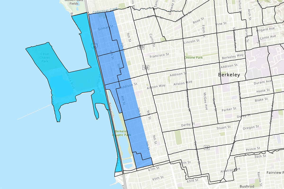
The $600,000 study, done by KLD Associates, also looked at tsunami evacuation along the Berkeley shoreline.
Funding for the analysis came from Measure FF (the 2020 bond measure to support fire and emergency services), the general fund and other monies.
Evacuation times were estimated for two types of tsunami warnings, based on the potential impacts: large waves and flooding.
The more severe warning, called "Max Phase" (from the National Tsunami Warning Center), would trigger an evacuation from the San Francisco Bay to Seventh Street.
Evacuating this area would take between an hour and 50 minutes to two hours and 15 minutes, the study found.
A lesser warning, called Phase 3, would apply to Berkeley areas west of Interstate 80.
Evacuations here would take between 55 minutes and an hour and 45 minutes, the study estimated.
Like for wildfire, tsunami evacuations can be hindered by clogged traffic. But unlike wildfire, there isn't such a thing as "tsunami weather" offering a window for pre-event evacuation.
Tsunami warnings happen after events occur. Though earthquakes are the usual trigger that starts the clock for projecting tsunamis and their impacts.
Evacuation planning is also the best tool for people who could be impacted by a tsunami, Lana said.
And, unlike during wildfires, the city does recommend biking and walking away in case of a tsunami warning.
"So they can quickly leave as evacuation orders are issued. ," she said, adding: "We expect traffic congestion during a tsunami, as we saw on Dec. 5, 2024. If you are able to walk or bike out, these can be great options for tsunami evacuations."
Tsunamis are rare in California and catastrophic damage is unlikely this far from the open ocean.
But Berkeley has experienced a few tsunamis in recent years, and some impacts.
In December last year the city was under a tsunami warning (potential waves of 3-feet and greater) triggering an evacuation, which was ultimately cancelled and caused a lot of confusion.
In 2022, and in 2011, tsunami advisories were issued with some flooding along the waterfront and marina areas due to waves up to 3 feet.
The Scanner will continue to report on the city's guidance around evacuations as developments occur.
Berkeley emergency workshops are coming
As Berkeley enters what's often considered its fire season, late summer into fall, the city is holding a series of emergency planning workshops. Registration is required.
Household Fire Weather Planning Workshops
- When: Tuesday, Aug. 19, 7-8 p.m.
Where: Zoom only
Details: Register online - When: Thursday, Sept. 4, 5-6 p.m.
Where: North Branch Library
Details: Register online - When: Monday, Sept. 15, noon to 1 p.m.
Where: Claremont Branch Library
Details: Register online
Family Emergency Preparedness Workshop
This event is designed for families with children.
- When: Saturday, Oct. 4, 11 a.m. to noon
Where: Claremont Branch Library
Details: Register online